A Personal Perspective
The Southwest is a special place that holds many positive memories for me. From aspen trees in the San Juan Mountains of southwestern Colorado, to the canyons along the Colorado River, to the Pacific beaches of Baja California, I have been fortunate to have traveled to the Southwest for many years and to explore my interests more deeply each time I return. Back home in the Washington, D.C. area, friends, relatives, and acquaintances have expressed their interest in the images and stories I bring back. The images presented here are what nature has allowed me to find and share. The stories are from my personal experiences, and do not attempt to provide a complete description of this interesting part of the North America. After seeing the images and reading through these accounts, I hope the reader will have a better idea of what the Southwest is about and how unique a place it is. I hope you enjoy looking through this site as much as I did bringing you the content.
My travels to the Southwest started in 1970, when I was involved with planning the family’s summer vacation. That year, we decided to go west instead of visiting the more traditional eastern destinations. The trip involved driving from Philadelphia and mostly following Interstate 80 west to San Francisco, south along California Route 1 (the Pacific Coast Highway) to Los Angeles, and east by way of Las Vegas, Arizona, Utah, and New Mexico. I was an excited kid embarking on this trip, felt like one of the pioneers going west, and had no idea about what I was to experience.
This life-altering trip can be reduced to one memory that made me want to come back again and again:
We were driving in southern Utah, from point A to point B, and had to travel through Zion National Park. Having no idea what Zion National Park was, our reaction was “Oh, that’s nice, there’s a National Park on the way… how convenient.” We entered the park from the east, where domes of orange-red-brown rock emerged from the earth in strange flowing textures. The colorful rock against the brilliant blue sky was like a neon sign; and the sign became larger as we continued west. We followed this once shallow canyon until we reached a tunnel carved into the rock. The domes and cliffs were large at the tunnel entrance: hundreds of feet high… nice scenery… nothing like this back east. The tunnel was narrow, two miles long, and had a few view ports in its northern walls that punctuated the darkness with shafts of orange-brown and blue light. Coming out the other end, we were suddenly in the main gorge of Zion National Park with shear 3000′ to 4000′ walls of that now familiar orange-red-brown rock. … stunning … impressive … overwhelming … We pulled over to take a look at the rock close-up. Tiny millimeter-size sand grains were glued together somehow to make up those massive cliffs.
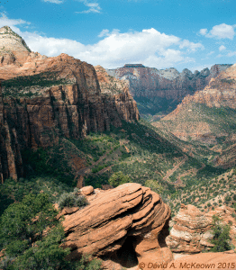
Zion Canyon Overlook 835-15: Zion National Park, Utah.
We would later learn that the Virgin River carved Zion Gorge, which cuts through some of the thickest Navajo sandstone deposits in the Southwest. We entered the park that first time to be stunned by a dramatic change in scenery that can be typical of and yet unique to the Southwest. This experience and a long growing list of other memories have made me return to this region almost every year.
When visiting the Southwest for the first time, one notices that nature truly dominates man and anything man-made. This may come as a shock, especially to those of us from urban areas in the eastern United States. However, it eventually becomes clear that man is a part, though be it a small part, of the whole. I feel that it is good to be reminded of this; and in the Southwest, one is reminded of it as subtly as being hit over the head with a sledge-hammer.
An impressive aspect about the Southwest is that it is so vast that no one can see or experience it all in a lifetime. During each visit, I see something new and am amazed by the endless variety of experiences. In the Southwest, nature’s vastness is easy to appreciate from the landscapes alone. However, if one considers the time involved to create this scenery, the vastness takes on more impressive dimensions. Without reading geology books, it is clear when visiting the Southwest, that nature works on a very different time-scale than our daily, weekly, monthly, or yearly concerns. From nature’s vastness in size, variety, and time, there is a fundamental truth or reality that is easy to appreciate while being in the Southwest and so easy to forget when back east in “civilization”*. This perspective has been a personal reference point, especially when life back home seems too irrational, crazy, or out of control to cope with. For me, a trip to the Southwest places everything back into proper perspective. I am not a religious person, but I view this region as a place to worship, to feel welcome, to be one with nature, and to be a small part of something infinitely larger than mankind.
This place can be addictive for some travelers, including yours truly. Over the years, I had the opportunity to see new places and probe deeper into the backcountry, where the scenery and experiences can be considerably more rewarding than what is seen just off the highway. However, the term “highway” takes on very different meanings in the Southwest.
* I may be using the term “civilization” too loosely here according to one Arizonan. One spring, I stayed in the small town of Gisela, Arizona, north of Phoenix. Arriving at the Restaurant-Bar-Hotel-Dance-Hall in downtown Gisela, I said to the caretaker, “This is a nice break from civilization.” Knowing that I was from Washington, D.C., she quickly responded, “THIS is civilization, where you’re from is a jungle.” … I stood corrected.
Getting There
There are different ways to travel west if you start in the eastern United States, but to me the most memorable way is by car. Many of the happiest times in my life were during those road trips heading west in anticipation of sights and experiences to come. This especially happened driving across the plains, where the countryside was becoming interesting while the humidity was left behind. The Sand Hills of western Nebraska is a place where one begins to see yucca and prickly pear cacti growing wild. Driving across the plains of western Kansas and eastern Colorado, I would try to pick out the snow-capped Rockies from clouds on the distant western horizon. In central Texas, the dry air, limestone canyons, and desert vegetation suddenly merge west of San Antonio. These memories are relived whenever I hear music that was played on the radio during those magical drives west. Unlike many other aspects in life, the excitement and anticipation during those trips have been fulfilled well beyond anything I could have imagined.
Memorable landmarks seen during these journeys come to mind which signaled that I was in the West, or at least approaching it. Scott’s Bluff and Chimney Rock in western Nebraska and the Badlands of South Dakota are the first distinctive landmarks one sees heading west in the northern plains and indicate the beginning of interesting territory to come in Colorado and Wyoming. The dramatic front range of the Rocky Mountains in Colorado was another indicator that I was in the west. However, the most memorable landmark, that said “welcome to the Southwest”, is El Capitan of the Guadalupe Mountains in western Texas. Once a tropical reef, this limestone promontory is a monument to Permian geology, and is the remains of re-crystallized fossil shells and exoskeletons of billions of sea creatures that lived over 200 million years ago. The promontory, El Capitan, impressively rises approximately a mile above the surrounding salt flats of the desert floor; its distinctive profile can be seen for 100 miles on the approaching highways from the east or west, and can be easily recognized from the air. This landmark is the southern terminus of a limestone reef formation that comprises the highest point in the state of Texas at Guadalupe Peak, and stretches northeast at least some 30 miles to Carlsbad Caverns in southeastern New Mexico.
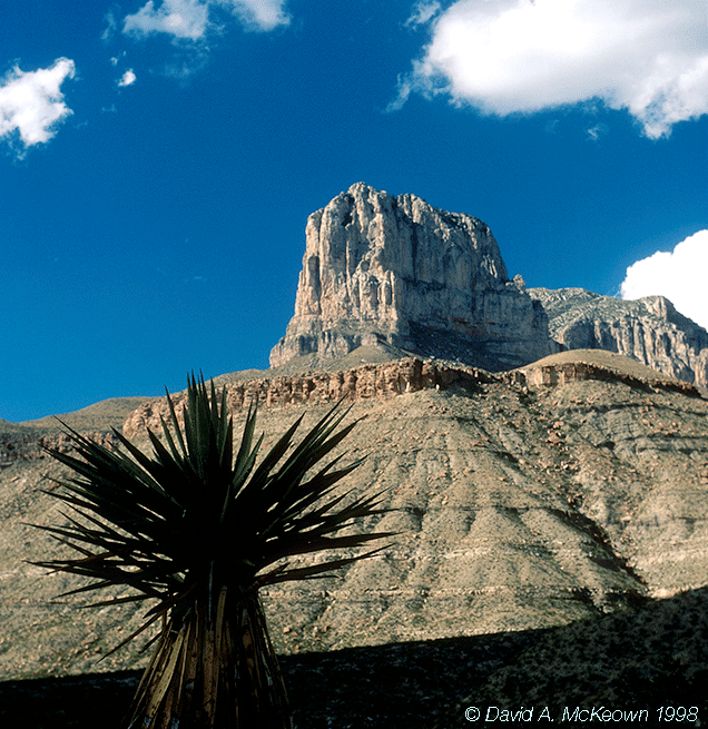
El Capitan 15-98: Guadalupe Mountains, National Park, Texas.
Background
The Southwest is unique mix of canyons, mountains, sandy deserts, clean blue skies, and colorful people. The flora and fauna that live there can range from tropical to alpine, depending on elevation. Simply described, the region has been uplifted and pulled apart recently in geologic time (during the last 40 million years) to create two distinctly different physiographic provinces or landforms: Colorado Plateau or the up-lifted part and basin-and-range or the pulled apart part. The Colorado Plateau has many canyons carved deeply into its “layer cake” geology by the Colorado River drainage, is dominated by sedimentary rocks, and surrounds the four corners area of northeastern Arizona, southeastern Utah, southwestern Colorado, and northwestern New Mexico. Typical basin-and-range areas have parallel mountain ranges separated from each other by basins, and are found in western Utah and Nevada, as well as southern and western Arizona. The basin-and-range continues into northwestern Mexico, including Baja California, where it marches into the Pacific.
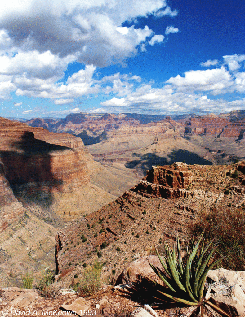
Hermit Trail Agave 25-93: Grand Canyon National Park, Arizona.
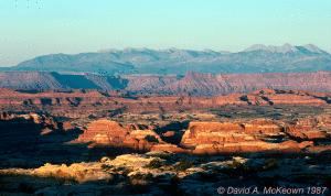
Land of Standing Rocks 10-87: Sunset in Canyonlands National Park, Utah.
Places to see layer cake geology typical of the Colorado Plateau are found in Grand Canyon National Park, Arizona and Canyonlands National Park, Utah, where the Colorado River and its tributaries form extensive canyon complexes.
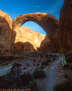
Rainbow Bridge 11-90: Rainbow Bridge National Monument, Utah.
Rainbow Bridge, National Monument, Utah is one of the more remote and memorable locations on the Colorado Plateau. Being comprised of sandstone, this is one of the world’s largest natural bridges. Rainbow Bridge spans 275′, reaching a height of 290′ above Bridge Creek. I have been told that the Capitol dome in Washington, D.C. can fit underneath its arch. This image was taken at sunrise and was the culmination of a 5 day 40 mile hike on the Rainbow Trail around nearby Navajo Mountain.
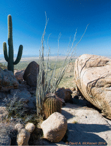
NorrisTrail 984-14: Saguaro National Park (West), Arizona.
Saguaro National Park West outside of Tucson, Arizona is typical of the low desert, basin and range areas in Arizona. This image was taken from the Norris Trail in early afternoon and shows typical low desert vegetation: saguaro cactus on the left, ocotillo (gray branches) in the middle, and barrel cactus in the lower middle. The landscape is dominated by granitic boulders.
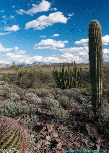
Organ Pipe 28-13: Organ Pipe Cactus National Monument, Arizona.
Another example of basin and range territory can be seen in Organ Pipe Cactus National Monument. Here a variety of cacti can be seen such as: the saguaro (far right), organ pipe (right of center), and barrel cactus (lower left).
A Word About Time Zones
The Southwest is mostly within the Mountain Time Zone. Parts of western Texas (east of the Guadalupe Mountains) are in the Central Time Zone. California and Nevada are in the Pacific Time Zone. This is simple enough, until you consider Arizona.
Most of the state of Arizona does not follow daylight savings time, because there is so much sunshine there all year. Arizona is therefore on Mountain Standard Time all year long… except in the northern part of the state, where it can become a little complicated during certain times of the year. In the northeast corner of the state, the Navajo Reservation (or Navajo Nation) does follow daylight savings time, and is therefore, one hour later than the rest of the state from March to November. The Navajo practice this, I am told, to keep their entire reservation on one time, as parts extend into Utah and New Mexico, where daylight savings time is observed. The Hopi Reservation and its people, are surrounded by the Navajo Nation, and of course, are not like the Navajo, and therefore, do not follow daylight savings time. Time becomes even more complicated considering that some Hopi citizens and individual villages are within the Navajo Reservation. For example, the town of Tuba City, Arizona, which is in the Navajo Reservation, has Hopi residents; this is where crossing the street can prompt a change from Mountain Standard to Mountain Day Light time… of course, depending on the time of year. If one took a drive in northern Arizona southeast from the town of Page through the Navajo Nation by way of the Hopi Reservation to Winslow, Arizona, one would technically go through at least four time changes when daylight savings time is in effect, and through no time changes during the rest of the year.