Just like in life, one thing can lead to another while traveling in the Southwest. My introduction to Havasu Canyon was during a flight tour that performed a large figure 8 over the Grand Canyon. The highlight was seeing a multi-tiered canyon (below) with tiny waterfalls cascading over a green carpeted floor. Looking out the plane window, my reaction was: “I want to go there.” Going there became a reality the next year as well as 21 years later. Those tiny waterfalls are as high as 191′ and are fed by Havasu Creek.
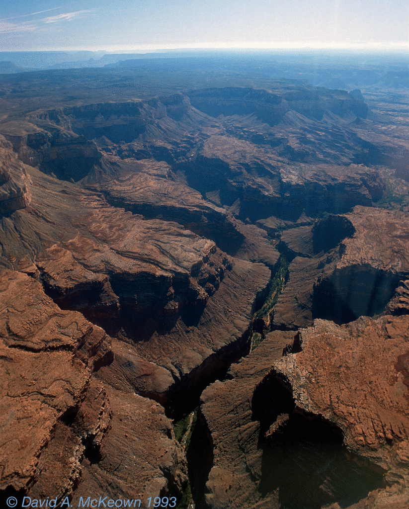
Havasu Canyon 32-93: View of Havasu Canyon from the air.
A trip to the village of Supai
It is difficult to believe that anyone can find a home in the generally barren, dry, and remote environments in the Grand Canyon. However, the village of Supai has been in the Grand Canyon for many centuries. Supai is not in a part of the Grand Canyon that most tourists see, but is located where Havasu Creek flows; and that is the secret: Havasu Creek is spring fed and flows all year long… sometimes with too much water.
As the crow flies, the distance between the popular Grand Canyon Village on the South Rim and Supai is not much more than 30 miles. However, following paved roads between these two points, is a 220 mile journey on Park Service, Interstate, State, and Reservation Highways. Along this way, one travels west on a relatively flat, open 35 mile stretch of Route 66, that is maintained by Arizona. Arriving at an intersection near Peach Springs, one takes a right on to Hualapai Reservation Route 18 and proceeds northeast for 80 miles through high plateaus of scattered pine forests, sage, and prickly pear cacti. Along this road one can barely see the tops of distant northern cliffs of the Grand Canyon. The pavement ends at Hualapai Hilltop: a collection of metal buildings, heavy equipment, parking lots, and helicopter pads. Traveling north from this point, highway vehicles give way to hiking boots, mules, horses, or helicopters. Hualapai Hilltop is also where the U.S. Mail is still carried in to and out of Supai daily by mule and horse trains. A special “parking” area is reserved for Postal Service animals near the trailhead leading to Supai. Helicopters landing and taking off is a common sight, where supplies and people are constantly being shuttled back and forth between Supai and Hualapai Hilltop.
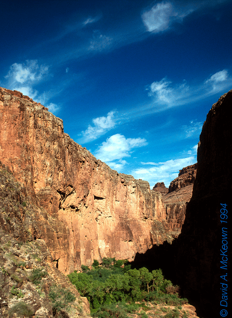
By the trailhead at the Hilltop, a sign says eight miles to Supai. The trail switch-backs down 800′ onto the floor of Hualapai Creek Canyon that merges with Havasu (or Cataract) Canyon. This part of the trail is usually dry, hot, and exposed to direct sunshine, but was cool during my hike due to overcast skies and scattered showers. Surrounding this part of the trail are agaves, yucca, prickly pear cacti, and sage, as well as buff and red colored sandstone and limestone cliffs. Mt. Sinyala, a distinctive landmark in this part of the Grand Canyon, is seen to the north. As one continues, the trail becomes shadier while the canyon deepens; this is where the vegetation becomes green, leafy, and more dense as water starts seeping out of the canyon walls. At the confluence of Havasu Canyon and Hualapai Creek canyon, the floor is covered with grasses and trees. Taking a left at the confluence, it is not long until running water is heard. Another mile or so downstream, the trail parallels the creek, crosses irrigation channels, and passes by trees, crop fields, and houses. A welcome sign greets the traveler entering the village of Supai, where instead of cars, the horse was the preferred form of transportation. Nearly everyone seemed to be on a horse, even children. This was in 1994. Since then, all terrain vehicles have become the transportation mode of choice in Supai. I was staying at the Havasupai Lodge on the opposite side of town and walked through “the business district” that has an open area flanked by the village grocery and cafe. The Lodge was just like any other modern motel, except there were no parking lots for guests and horses were grazing on the lawns.
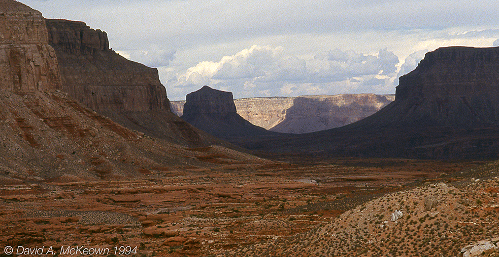
Havasu Canyon 11-94: Mt. Sinyala in shadow while hiking in Hualapai Creek Canyon to Supai.
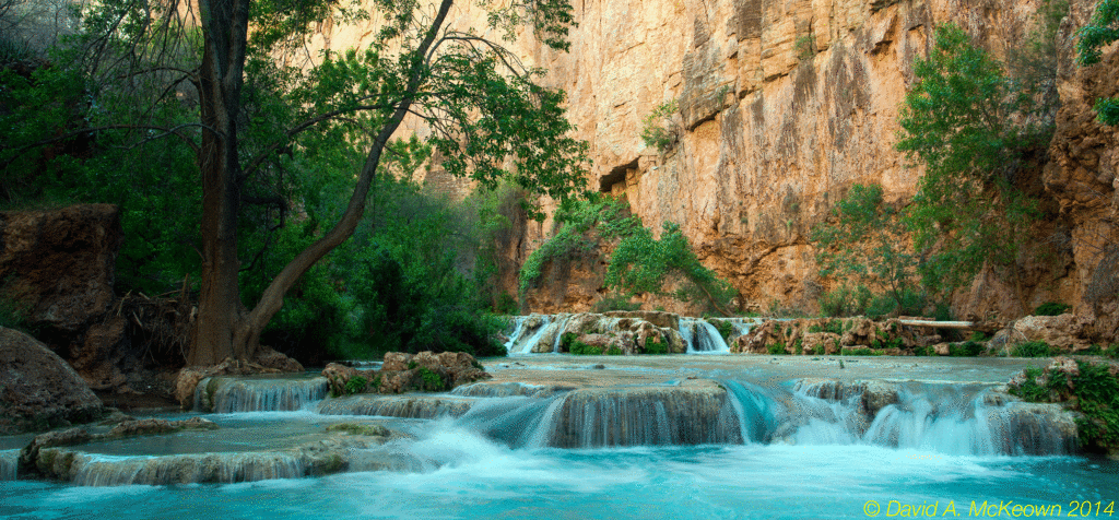
Down stream of the village are the main attractions: three water falls and the turquoise waters of Havasu Creek. This is where the canyon becomes deeper and narrower; and cave-like travertine formations are common anywhere the rust colored rock is exposed to water, especially in or near the creek channel. Calcium carbonate suspended in the water causes the blue-green color. A bizarre combination of micro-climates is seen here. There is so much moisture in the vicinity of the creek that the air is humid, so that green leafy plants can flourish on the canyon floor. A few hundred feet higher are prickly pear cacti, yucca, and agave, clinging to the cliffs and struggling to survive the harsh desert conditions.
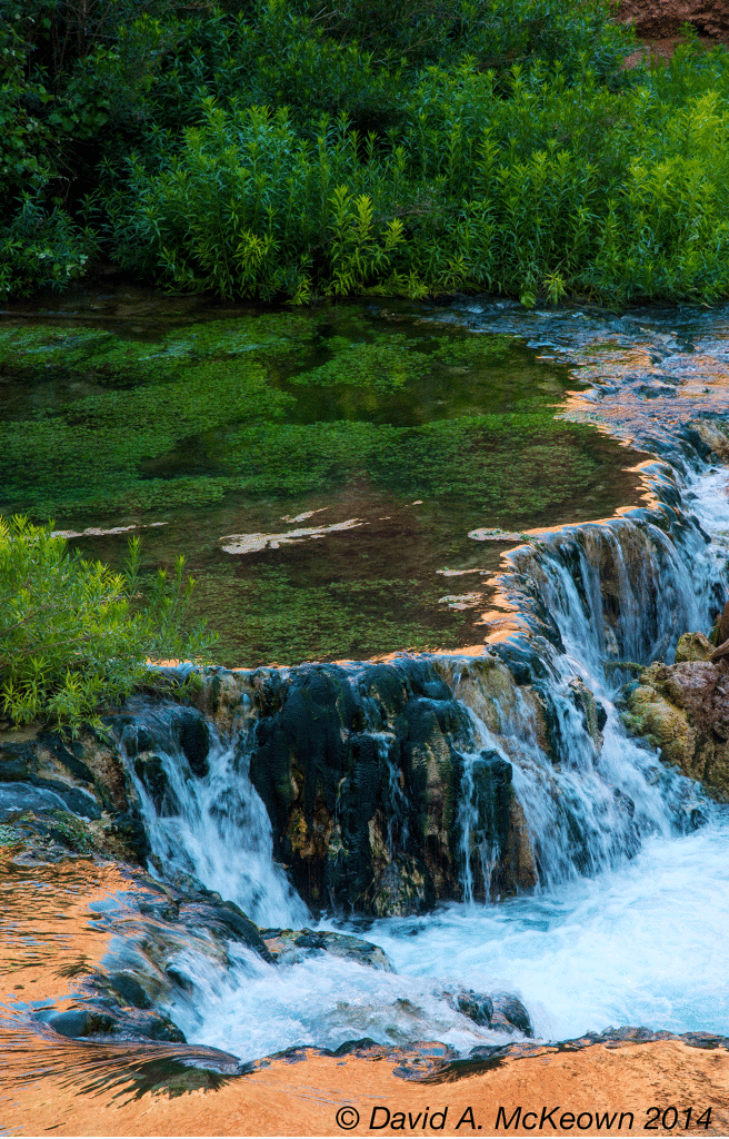
Havasu Creek 3175-14.
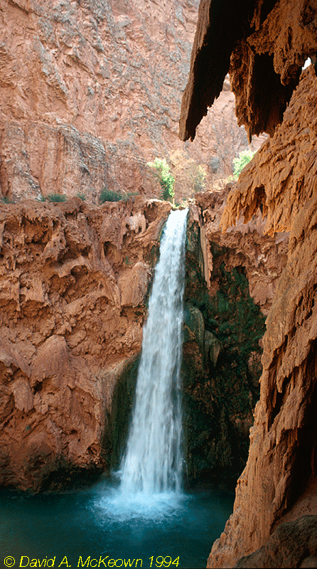
The three waterfalls, Navajo, Havasu, and Mooney, are seen in that order hiking downstream, and can change over time due to flash floods that wash away and rearrange rock formations as well as change the course of Havasu Creek.
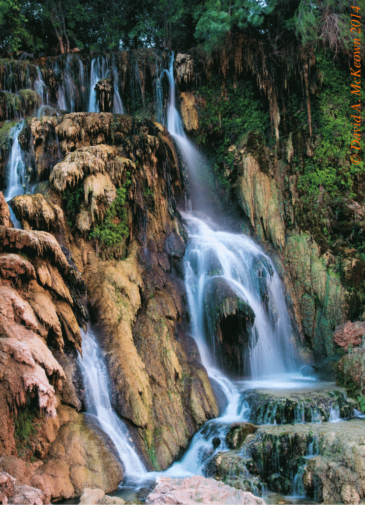
New Navajo 3062-14: Navajo Falls.
Havasu Falls, approximately 100’ high, is a stunning sight to see with tall canyon cliffs in the background. Many layered pools of turquoise water at the foot of the falls are used for wading and swimming. This is a popular destination for hot, weary hikers during the late spring and summer months.
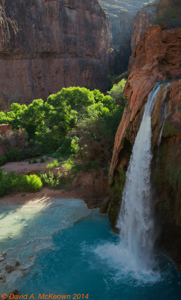
Havasu Falls 3637-14: During the hike out from camp in the early morning.
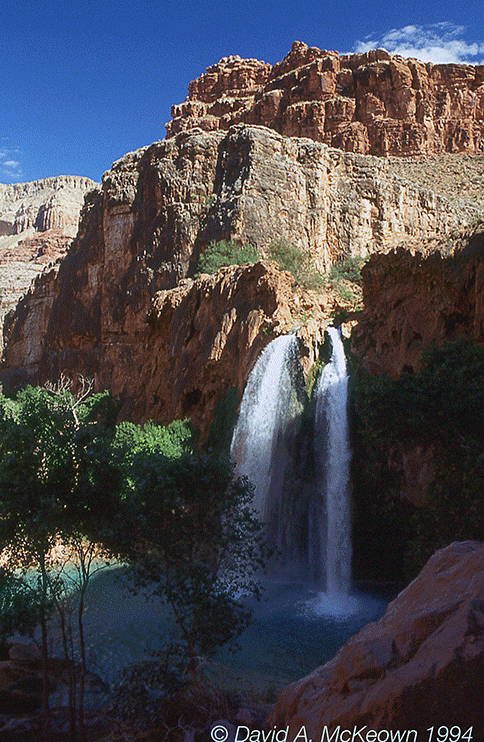
Havasu Falls 31-94: Havasu Falls 20 years earlier, before the 2008 flash flood.
The waters of Havasu Creek plunge 191′ at Mooney Falls, where the trail provides interesting challenges to reach good views of the falls and the canyon downstream. The falls are at a point where the canyon floor drops across its entire width.
Havasu Canyon 29-94: Looking down-stream from above Mooney Falls.
According to the Havasu Grand Canyon Trail Guide:
“The trail seems to end above Mooney Falls. But with care you can find your way below the falls by following an old miner’s route….”
The word “care” cannot be over-emphasized here. During my first visit, I found what the Guide said: the trail seemed to end in a sea of footprints above the falls, with no clear way down, until one discovers a hole in the ground. The trail goes into the hole, follows several narrow ledges, and goes into two steep narrow tunnels, where steps were carved and blasted out of the travertine rock. The steps had a tendency of being shallow (only a few inches deep) and spaced far apart vertically (by several feet). Below the tunnels, chains and drill bits embedded in the rock face provide the hand- and foot-holds, while the carved steps seem to become become shallower and wider apart. One must negotiate this while being on a cliff face with the bottom too far below to jump down to safely. I finally came to a point where I stood on a narrow step for several minutes. I was not sure whether to continue down or go back up, to face the cliff walls going down or walk down the steps with my back to the cliff. The steps were so wide apart that I could barely reach the next lower level (even with my long legs). It became unwieldy climbing down this wall while carrying a day-pack and camera bag. Suddenly, I was forced to make a decision: a small group of people congregated above me and looked down at me as if asking, “why did you stop there?” The canyon floor was still some 30′ below; so, I tossed down my camera bag, faced the rock wall, grabbed the drill bits, and felt my way down. On reaching the bottom, I looked at what I had just climbed down, and in a sudden panic, wondered if I could ever make it back up.
Mooney Falls 31-94.
It was time to place the panic aside, take photographs, walk down the trail, and eat lunch. The trail continued on the west side of the creek, past a deep pool and boulders at the base of Mooney falls. Shallow pools of turquoise water were at my feet while the canyon walls soared to what appeared to be a couple thousand feet above me. After lunch, I decided to make my attempt at the cliff face. I firmly grabbed the drill bits and steadily climbed back up through the tunnels to the top. As it turned out, the hike down was much more difficult physically and emotionally than the return up.
Havasu Creek 3218-14: Havasu Creek below Mooney Falls.
My two day visit at Supai was coming to a close; and it was time to hike out early the next morning. After bandaging a torn toenail, having a good night’s sleep, and eating breakfast at the cafe. I left Supai at 7:00 AM to race the heat and sun that would greet me during my journey to the Hilltop. The change in elevation from Supai to the Hilltop is over 2000′, where the last mile on the trail is the steepest, driest, and hottest. The earlier I would leave Supai, the more cool and pleasant the last miles of the hike would be. The cool air in Havasu Canyon and at the confluence made the first half of the hike out enjoyable. Several groups of people from Supai passed me as they were coming down the trail; one woman commented about how fresh I looked now, but how tired and hot I would be once I reached the parking lots at the Hilltop. As I continued south, the canyon walls fell away, the water disappeared, the views opened up to wide vistas, and the air became dry and hot. Every mile or so, a mule train passed me carrying the mail. The final 800′ climb out was a hard one in the heat. I finally reached the parking lots after racing a mule train to the top, approximately four and a half hours after leaving Supai. I felt exhilarated when I reached my car, gladly took off the hiking boots, and drank some great tasting warm fruit juice that was sitting in the hot car for a few days. The drive out on Route 66 and my lunch near a forest’s fire tower, were happy memories on my way to my destination for the night in Kingman, Arizona, and the start of a needed rest for my feet.
Epilogue
Despite the primitive transportation, the mail service from Supai is good: maybe one of the more efficient parts of the U.S. Postal Service I experienced. As I was leaving, I mailed post cards at the Supai Post Office to friends and relatives in a variety of locations across the country. Within a week, everyone received their card with the special mule train postmark. A relative in Florida received their card within four days of it being sent. So, those mules knew what they were doing.
The service from Supai can out-class the Postal Service in the Nation’s Capitol. Eight days after it was sent, a business letter from the District of Columbia arrived at my home in Maryland (by way of Iuka, Illinois), some twenty-five miles away. Unfortunately, the mules were not involved with this mailing; and unfortunately for me, this was not my only disappointment with the slow postal service in the D.C. area.
Epilogue 2
Twenty years after my first visit to Havasu Canyon, I had the good fortune to visit the area again for an Arizona Highways Photo-workshop. This time, I helicoptered in and out of Supai with the workshop group.This trip allowed me to appreciate not just the waterfalls that attract everyone’s attention, but the beauty of Havasu Creek itself. In the morning light, the creek glows shades of gold from the reflection of sunlight off nearby canyon cliffs. The colors on the water’s surface with the green vegetation provide images that no one (familiar with Havasu Canyon) would suspect are from Arizona.
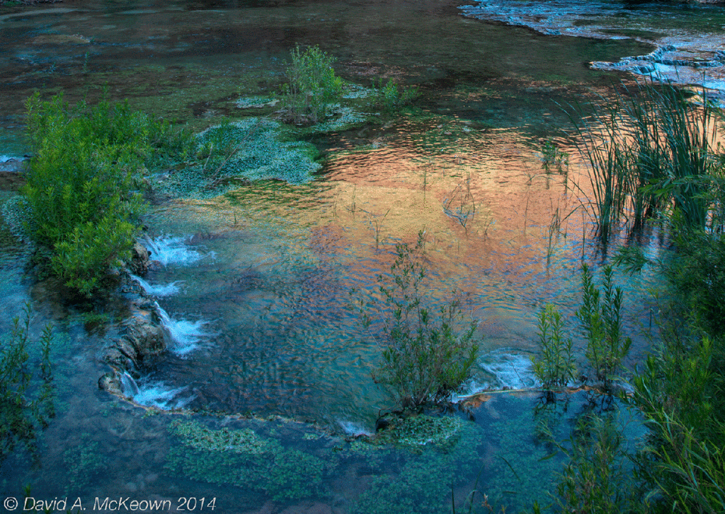
Havasu Creek 3137-14: Golden reflections in the morning.
This visit also allowed me to experience the climb down that cliff face by Mooney Falls one more time and to explore more of Havasu Creek downstream. This time the climb down was assisted by ladders, which meant standing on fewer drill bits. However, I was no less terrified negotiating this part of the canyon than that first time 20 years earlier.
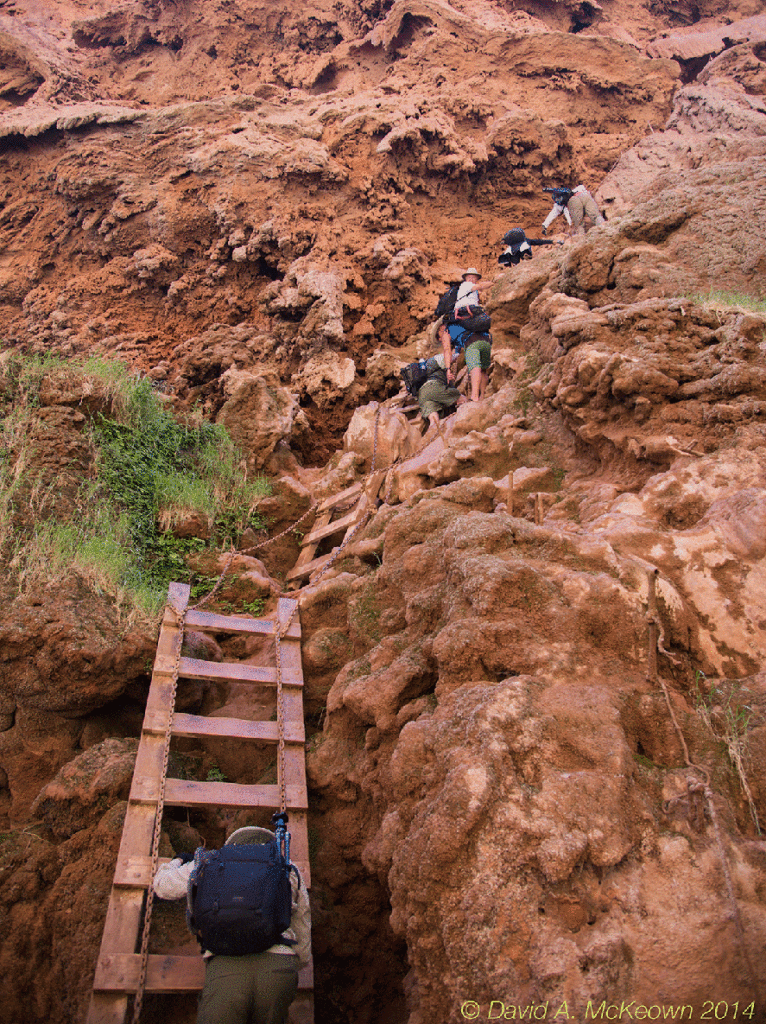
Mooney Falls 3202-14: The adventure down the cliff to the base of Mooney Falls.